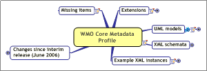
CBS-Ext.(06) agreed version 1.0 of the WMO Core Profile
of the ISO Metadata Standard.
This document presents the extensions to the ISO
Metadata Standard.
|
|
|
|
|
A number of extension points were identified: |
|
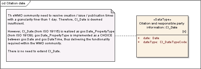
The WMO community need to resolve creation / issue / publication times with a granularity
finer
than 1 day. Therefore, CI_Date is deemed insufficient.
However, CI_Date (from ISO 19115) is realised as gco:Date_PropertyType (from ISO 19139).
gco:Date_PropertyType is implemented as a CHOICE between gco:Date and gco:DateTime, thus
delivering the functionality required within the WMO community.
There is no need to extend CI_Date.
|
|
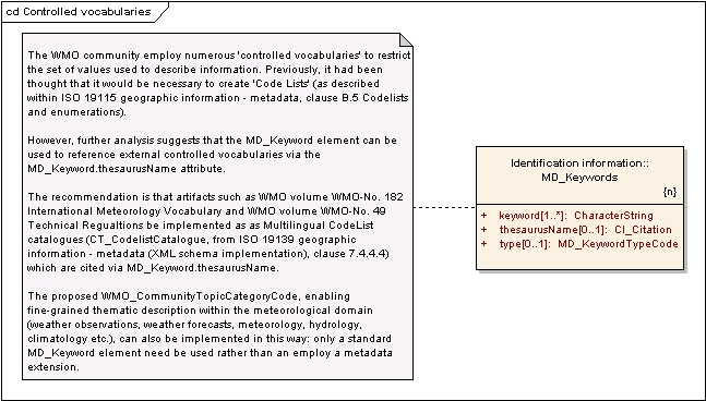
The WMO community employ numerous 'controlled vocabularies' to restrict the set of
values used
to describe information. Previously, it had been thought that it would be necessary to create 'Code
Lists' (as described within ISO 19115 geographic information - metadata, clause B.5 Codelists and
enumerations).
However, further analysis suggests that the MD_Keyword element can be used to reference
external controlled vocabularies via the MD_Keyword.thesaurusName attribute.
The recommendation is that artifacts such as WMO volume WMO-No. 182 International
Meteorology Vocabulary and WMO volume WMO-No. 49 Technical Regualtions be implemented as
as Multilingual CodeList catalogues (CT_CodelistCatalogue, from ISO 19139 geographic
information - metadata (XML schema implementation), clause 7.4.4.4) which are cited via
MD_Keyword.thesaurusName.
The proposed WMO_CommunityTopicCategoryCode, enabling fine-grained thematic description
within the meteorological domain (weather observations, weather forecasts, meteorology,
hydrology, climatology etc.), can also be implemented in this way: only a standard MD_Keyword
element need be used rather than an employ a metadata extension.
|
|
The WMO Community express the need to use 'hierarchical' keyword taxonomies - such
as
NASA's GCMD Science Keywords
[http://gcmd.nasa.gov/Resources/valids//gcmd_parameters.html] - in order to describe geographic
information.
To achieve this, the standard CharacterString element has been extended to add a delimiter
(token)
between 'levels' in the hierarchy.
The delimiter can be specified at the instance document level, but has default value
= "|".
Example:
GCMD keyword:
EARTH SCIENCE > Atmosphere > Air Quality > Smog
XML serialisation:
<MD_Keywords>
<keyword>
<wmo:DelimetedString delimiter="|">EARTH SCIENCE | Atmosphere
| Air Quality |
Smog</gco:CharacterString>
</keyword>
</MD_Keywords>
|
|
Within the WMO community, ANALYSIS TIME is often used to differentiate between datasets
from
numerical simulations.
The analysis time is considered to be a time instant.
This extension provides an analysisTime attribute that can be used to identify a particular
dataset.
|
|
Within the WMO community information atrifacts (particularly weather forecasts) are
perishable;
that is they are only valid for a fixed period of time after issue as another, potentially more accurate
forecast is likely to have been issued.
In particular, aviation weather forecasts are valid for only a specific period as
defined by the
Internation Civil Aviation Authority (ICAO)
This extension enables one to specify the time period during which the dataset is
valid. Outside
this time period, the dataset must not be used for operational purposes.
|
|
UML is the canonical notation used in the ISO 19100 series of standards for Geographic
Information developed by ISO/TC 211. However, UML provides a rich palette, and even within class-
diagrams the UML elements may be combined in a variety of ways to represent similar functions.
In order to restrict the variability, a strict "profile" of UML is used. This is defined primarily
in ISO
19103, with some contextual clarification in ISO 19109, 19118 and 19136. |
|
"WMO Core Metadata Profile - Extensions" builds on the "HollowWorld"
model developed within
the SEEGrid community.
The primary resource is the "WMO Core Metadata Profile - Extensions.EAP"
file, which is a UML
template in "Enterprise Architect" format.
+++++
The WMO Core Profile Metadata Extensions can be found by browsing the 'Project View':
Model > HollowWorld > WMO Core Metadata Profile |
|
A discussion concerning the application of HollowWorld can be found at the following
link: |
|
Model documentation (exported from Enterprise Architect) can be found at the following
links;
either as RTF or HTML |
|
|
|
|
|
|
|
The XML Metadata Interchange format allows a model from one tool to be exported (as
XMI) and
imported into another tool.
"wmo_metadata_extensions.xmi" has been exported from "Enterprise Architect"
UML modelling
tool via the "XML Model Interchange" format; UML 1.3, XMI 1.0.
|
|
|
|
|
|
|
|
The extensions illustrated within the UML model have been serialized to W3C XML schema.
The serialisation is (believed to be) compliant with ISO 19139 'geographic information
- metadata
(xml schema implementation)' clause 8 'ecoding rules' and clause A.3 'conformance requirements -
extensions'. |
|
|
|
|
|
|
|
|
|
|
|
|
|
Note that external schema are referenced at source (i.e. http://www.isotc211.org/2005).
The WMO
extensions schema is referenced locally (../wmo/wmo_metadata_extensions.xsd) as it is yet to be
published externally.
oXygen uses the java Xerces XML Parser from apache.
Due to issues regarding the 'clash' between GML 3.1.1 and ISO19139 (schema packages
seem to
be imported multiple times) the 'honour-all-schemaLocations' was turned OFF [Options > XML
Parser > XML Parser Features > http://apache.org/xml/features/honour-all-schemaLocations]
For more details on Xerces, refer to:
The 'honour-all-schemaLocations' feature is discussed at:
|
|
Vector Smart Map level 0 (VMAP0); from ISO 19139 'geographic information - metadata
(xml
schema implementation)' clause D.3 |
|
The examples included here are acknowledged as being incomplete.
The subject 'domain' of the examples are aviation forecasts: Terminal Aerodrome Forcasts
(TAFs)
as currently exchanged on the GTS.
The TAFs used within the examples are described in the following document: |
|
ukmo.jedds.taf.xml
and ukmo.jedds.metar.xml
are supposed to represent a rolling ‘archive’ of TAFs
& METARs (respectively) … global geospatial extent & including the last 3 days-worth of
bulletins |
|
|
|
|
|
|
|
int.wmo.wis.taf.TTAAii.xml
represent TEMPLATEs for TAF bulletins that are exchanged on the
GTS … the idea is that these metadata records will be exposed on the WIS catalogue thus
allowing users to subscribe to this bulletin for regular delivery |
|
|
|
|
|
|
|
|
|
|
|
|
|
|
|
|
|
|
|
|
|
|
int.wmo.wis.taf.TTAAii.CCCC.ddHHMM.nnn.xml describe
SPECIFIC instances of TAFs that are
exchanged on the GTS … much bigger than the TAF bulletin itself, but we may need to pass
standards-compliant metadata with the data if users request the information |
|
|
|
|
|
|
|
|
|
|
|
|
|
|
|
|
|
|
|
WMO_DelimitedString:
- changed name (from WMO_DelimetedString)
to correct spelling mistake.
- new mandatory isoType attribute (fixed
value "CharacterString") indicating the ISO class which
it extends from
Attribute delimiter:
- changed name (from delimeter)
to correct spelling mistake
- now has default value "|"
|
|
WMO_SimulationDataIdentification:
- changed name (from WMO_SimulationIdentification)
to improve semantics.
- new mandatory isoType attribute (fixed
value "MD_DataIdentification") indicating the ISO class
which it extends from
|
|
WMO_UsagePeriodConstraints:
- new mandatory isoType attribute (fixed
value "MD_Constraints") indicating the ISO class which
it extends from
|
|
- There is no data dictionary included
in this documentation, although information describing the
extensions is provided here: model documentation
- Metadata extension information (describing
the extensions created for this WMO Profile) has
not been created; refer to ISO 19115 'geographic information - metadata' clause A2.11
'metadata extension information' for more details
- There is no mechanism in place to
link a metadata record that describes a dataset to the
service where the dataset can be accessed. The so-called 'service metadata' is out of scope
for this release.
|
|
|
|
|